(This functionality is available with the Computations
module)
Creates points in a grid, by specifying its grid size, interval, direction, distance and elevation.
To run this option, select the Create/Point command and the Method/Plane Grid command from the Computations task to display the relevant wizard.
The points to be created will be given the attributes currently defined via the Attributes/Point command. You should use that command to set the required attributes before creating any points.
Important: Refer to the Creation Methods-Special Notes topic and ensure that you are familiar with its contents.
Create Points by Plane Grid Wizard
| Item | Used to |
| Point ID buttons | Key in the point identifier of the point to be created. The point identifier may also be determined by using the Next or Last buttons. |
| Auto No: | Specify that the point numbers will be generated automatically from what is currently in the system or from what is entered in the Point ID edit field below. |
| or | |
| Local Co-ords: | Specify that the point numbers will be generated from the interval entered i.e. 50/20. |
| or | |
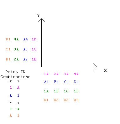
| Reference ID: | Specify that the point numbers will be generated from what the user
enters in the X and Y fields below. Any alpha (A, a) or numeric can be entered in the two fields. For example, if a typical point number is to be A1, place A in the X field and 1 in the Y field and they will both be incremented separately in both directions. |
 |
|
| X Precedes Y: | Choose which direction the Point Numbers are going to run, either
along the X or along the Y axis. Please note that this applies to all three Point ID generation options. |
| < Back | Go to the last wizard page Size and Interval. |
| Next > | Go to the next wizard page Elevation. |
| Cancel | Cancels and closes the wizard. |